


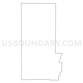
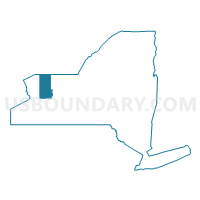
Genesee & Orleans Counties PUMA, New York
About
Outline
Summary
| Unique Area Identifier | 193506 |
| Name | Genesee & Orleans Counties PUMA |
| State | New York |
| Area (square miles) | 1,312.73 |
| Land Area (square miles) | 884.20 |
| Water Area (square miles) | 428.53 |
| % of Land Area | 67.36 |
| % of Water Area | 32.64 |
| Latitude of the Internal Point | 43.23597230 |
| Longtitude of the Internal Point | -78.21647670 |
Maps

Graphs
Select a template below for downloading or customizing gragh for Genesee & Orleans Counties PUMA, New York


Neighbors
Neighoring Public Use Microdata Area (by Name) Neighboring Public Use Microdata Area on the Map
- Erie County (Northeast) PUMA, NY
- Livingston & Wyoming Counties PUMA, NY
- Monroe County (North & West) PUMA, NY
- Niagara County (North & East) PUMA, NY
Top 10 Neighboring County (by Population) Neighboring County on the Map
- Erie County, NY (919,040)
- Monroe County, NY (744,344)
- Niagara County, NY (216,469)
- Livingston County, NY (65,393)
- Genesee County, NY (60,079)
- Orleans County, NY (42,883)
- Wyoming County, NY (42,155)
Top 10 Neighboring County Subdivision (by Population) Neighboring County Subdivision on the Map
- Ogden town, Monroe County, NY (19,856)
- Batavia city, Genesee County, NY (15,465)
- Sweden town, Monroe County, NY (14,175)
- Alden town, Erie County, NY (10,865)
- Hamlin town, Monroe County, NY (9,045)
- Newstead town, Erie County, NY (8,594)
- Albion town, Orleans County, NY (8,468)
- Attica town, Wyoming County, NY (7,702)
- Royalton town, Niagara County, NY (7,660)
- Le Roy town, Genesee County, NY (7,641)
Top 10 Neighboring Place (by Population) Neighboring Place on the Map
- Batavia city, NY (15,465)
- Medina village, NY (6,065)
- Albion village, NY (6,056)
- Le Roy village, NY (4,391)
- Attica village, NY (2,547)
- Oakfield village, NY (1,813)
- Holley village, NY (1,811)
- Bergen village, NY (1,176)
- Lyndonville village, NY (838)
- Corfu village, NY (709)
Top 10 Neighboring Unified School District (by Population) Neighboring Unified School District on the Map
- Churchville-Chili Central School District, NY (27,380)
- Brockport Central School District, NY (27,321)
- Batavia City School District, NY (19,073)
- Albion Central School District, NY (15,392)
- Alden Central School District, NY (14,052)
- Attica Central School District, NY (13,793)
- School District Not Defined, NY (13,644)
- Medina Central School District, NY (11,216)
- Akron Central School District, NY (9,659)
- Royalton-Hartland Central School District, NY (9,071)
Top 10 Neighboring State Legislative District Lower Chamber (by Population) Neighboring State Legislative District Lower Chamber on the Map
- Assembly District 142, NY (132,951)
- Assembly District 134, NY (130,126)
- Assembly District 139, NY (127,086)
- Assembly District 138, NY (126,488)
- Assembly District 131, NY (126,203)
- Assembly District 147, NY (124,739)
Top 10 Neighboring State Legislative District Upper Chamber (by Population) Neighboring State Legislative District Upper Chamber on the Map
- State Senate District 55, NY (309,516)
- State Senate District 62, NY (304,003)
- State Senate District 61, NY (303,809)
- State Senate District 59, NY (297,961)
- State Senate District 56, NY (297,343)
Top 10 Neighboring 111th Congressional District (by Population) Neighboring 111th Congressional District on the Map
- Congressional District 26, NY (674,804)
- Congressional District 27, NY (629,271)
- Congressional District 28, NY (611,838)
Top 10 Neighboring Census Tract (by Population) Neighboring Census Tract on the Map
- Census Tract 9702, Wyoming County, NY (7,702)
- Census Tract 406, Orleans County, NY (7,666)
- Census Tract 9504, Genesee County, NY (6,809)
- Census Tract 152, Monroe County, NY (6,736)
- Census Tract 407, Orleans County, NY (6,200)
- Census Tract 9503, Genesee County, NY (6,161)
- Census Tract 148.03, Erie County, NY (6,028)
- Census Tract 240.01, Niagara County, NY (5,985)
- Census Tract 149.03, Erie County, NY (5,873)
- Census Tract 9514, Genesee County, NY (5,692)
Top 10 Neighboring 5-Digit ZIP Code Tabulation Area (by Population) Neighboring 5-Digit ZIP Code Tabulation Area on the Map
- 14020, NY (23,306)
- 14420, NY (20,467)
- 14411, NY (14,491)
- 14004, NY (12,704)
- 14103, NY (11,183)
- 14011, NY (9,822)
- 14001, NY (9,464)
- 14482, NY (8,275)
- 14428, NY (8,096)
- 14470, NY (8,016)